
GNSS data comes from various national and regional GNSS networks. Many of them are part of the EUREF Permanent GNSS Network (EPN), sustained by EUREF, a European-level organisation that maintains a European Geodetic Reference Systems network. Other examples are the French RENAG (REseau NAtional GNSS permanent) and the Italian RING (Rete Integrata Nazionale GNSS) networks.
The Thematic Core Service GNSS Data and Products standardises and provides access to a variety of european and regional geodetic data, metadata, products, and software in support of Solid Earth Sciences. Activities and services are coordinated within the EPOS infrastructure to ensure interoperability with the GNSS gateways and EPOS' ICS data portal.
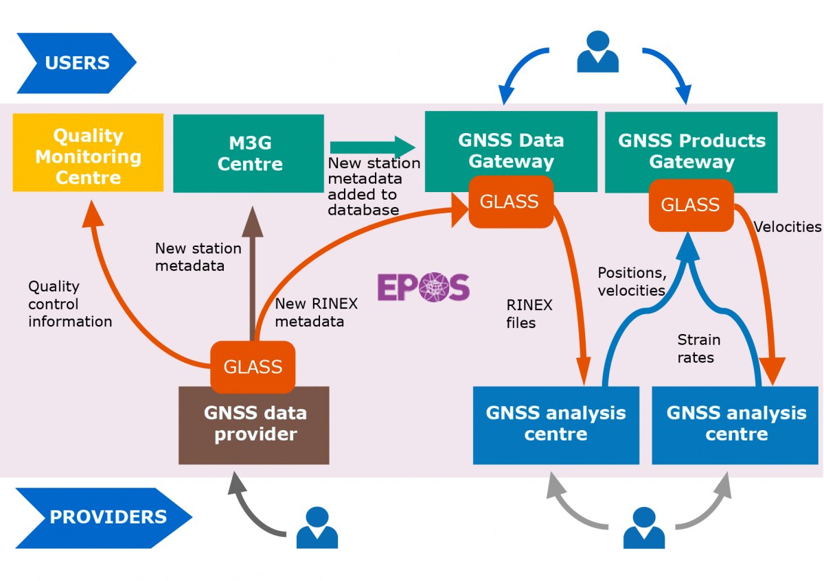
M3G
M3G stands for “Metadata Management and distribution system for Multiple GNSS Networks”. GNSS station managers use M3G to upload, validate, and distribute their GNSS station metadata such as IGS-style site logs, information about local networks, data owner, DOIs, data license, etc...
M3G's primary goal is to collect rich metadata as recommended by the FAIR data principles. M3G's metadata of EPOS-GNSS stations are provided to the EPOS-GNSS Data Gateway and are also available through M3G's APIs and web portal.
M3G is maintained by the Royal Observatory of Belgium as a common service of EUREF and EPOS.
GNSS Data Gateway Portal
The GNSS Data Gateway Portal is a virtual infrastructure to store and disseminate GNSS data and products from existing Research Infrastructures.
The portal stores EPOS stations metadata and enables access to the GNSS observations and products. GNSS data from all over Europe, including EUREF Permanent GNSS Network (EPN), is available in this portal. Users can select the stations of their interest and the corresponding set of metadata, such as station code, site name, longitude, latitude, elevation, and other information. Users can also select stations on the map, either by drawing a rectangle, a circle or a polygon around them, or providing bounding box coordinates.
GNSS Product Portal
Data from the GNSS Data Gateway Portal is validated and analysed in different GNSS analysis centres and made available in the GNSS Product Portal.
The portal enables access to the GNSS observations and derived products, such as daily and weekly time series, estimated velocities and strain rate maps from various regions in Europe. Graphical interfaces enable station visualisation and multiple queries over stations and associated metadata, allowing users to retrieve the desired information.
Data Quality Monitoring portal
The EPOS-GNSS data quality monitoring web portal is the public front-end of the “EPOS-GNSS Data Quality Monitoring Service” (DQMS) maintained by the Royal Observatory of Belgium. The DQMS monitors the availability and quality of the daily GNSS data that are made discoverable through the TCS “GNSS data and products”.
The information provided by the portal is used e.g., as feedback to GNSS data suppliers or as input to scientists interpreting the results of the GNSS data products. The DQMS portal provides maps and plots that are updated at least daily.
Data and products are provided to the TCS GNSS by six EPOS official analysis centres:
- LTK (Department of Geodesy, Remote Sensing and Land Offices – Government Office of the Capital City Budapest);
- INGV (Istituto Nazionale di Geofisica e Vulcanologia – Centro Nazionale di Terremoti, Rome, Italy);
- ROB-EUREF (Royal Observatory of Belgium, Belgium);
- UGA-CNRS (Université Grenoble Alpes, France);
- WUT-EUREF (Department of Geodesy and Geodetic Astronomy, Warsaw University of Technology, Poland); and
- LM (Lantmäteriet, Sweden)