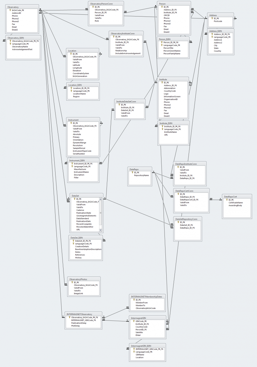
The Thematic Core Service Geomagnetic Observations offers a broad portfolio of services. Geomagnetism work under EPOS has also seen the creation of a community resource for Geomagnetic Observatory metadata, a system that supports various data services.
World Data Center for Geomagnetism (Edinburgh)
The World Data Center (WDC) has a comprehensive set of digital geomagnetic data as well as indices of geomagnetic activity supplied from a worldwide network of magnetic observatories. The WDC for geomagnetism actively engages with the geomagnetic community to grow its data collections.
The TCS Geomagnetic Observations works closely with the WDC to improve the metadata associated with observatory data, including geomagnetic observatory data and magnetic surveys.
International Monitor for Auroral Geomagnetic Effects (IMAGE)
IMAGE is a network of 41 magnetometer stations maintained by eight European institutes. These stations capture the profile of auroral electrojets, electric currents with an oval pattern that forms around the Earth’s poles and are controlled by the Earth’s magnetic field and its interaction with the solar wind. Besides, IMAGE also provides high-quality data useful for studies of geomagnetic induction and long-term geomagnetic activity in the auroral region.
Together with other ground-based recordings (by radars, riometers, all-sky cameras) and satellite observations, IMAGE is an essential part of the investigations of high-latitude magnetospheric-ionospheric physics.
The TCS Geomagnetic Observations consolidates geomagnetic variation data and the disturbance levels recorded by auroral zone magnetometers from the IMAGE network and integrates it within the EPOS’ platform.
INTERMAGNET
INTERMAGNET is a global organisation of geomagnetic observatories. This worldwide network provides permanent and consistent data from geomagnetic observatories. INTERMAGNET ensures that the recorded observations meet the quality requirements and data has the geographical coverage required to meet the evolving needs of research and applied science.
International Service of Geomagnetic Indices (ISGI)
The International Service of Geomagnetic Indices (ISGI) creates and disseminates geomagnetic indices, and organises tables of remarkable magnetic events, based on the report of magnetic observatories distributed all over the planet.
ISGI is a service of the International Association of Geomagnetism and Aeronomy (IAGA). The collaboration of ISGI Institutes ensures the quality and homogeneity of the data series.
- Services
| Service | Description | Leading institution |
| Electrical conductivity models | Electrical conductivity models are obtained as a result of inverse modelling of EM data, in particular magnetotelluric data. | LTU |
| Electrojet indicators for the IMAGE network | IMAGE electrojet indicators are simple estimates of the total eastward and westward currents crossing the IMAGE magnetometer network. | FMI |
| Event data from the International Service for Geomagnetic Indices (ISGI) | The International Service of Geomagnetic Indices (ISGI) is the service of the International Association of Geomagnetism and Aeronomy (IAGA). ISGI is the reference Service for validation, dissemination and stewardship of international lists of geomagnetic events detected at ground magnetic observatories. | EOST (CNRS) |
| Event indicators for the IMAGE network | IMAGE electrojet events refer to periods when a clearly detectable eastward and/or westward current crosses the magnetometer network. | FMI |
| Geomagnetic events | List of notable events in the record of Geomagnetc Data from the International Service for Geomagnetic Indices. | EOST/OE |
| Geomagnetic indices | Current and historical geomagnetic indices from the International Service for Geomagnetic Indices. | EOST/OE |
| Geomagnetic observatory data | Geomagnetic observatory data from the World Data Center for Geomagnetism (Edinburgh) and from the INTERMAGNET network. | BGS |
| Global geomagnetic survey data collected by the World Data Centre (WDC) | The World Data Centre for Geomagnetism (Edinburgh) is a node of the World Data System (WDS) established by the International Council for Science (ICSU). The WDC holds details of individual readings of the Earth's magnetic field ('spot values') made for the purposes of surveying and monitoring long-term changes in the field. The readings are world-wide and span over 100 years, with the European region particularly well covered. | BGS |
| Historical data | Data from variometer networks that are no longer operational. | FMI |
| IGRF and WMM global magnetic models | Access to the International Geomagnetic Reference Frame and the World Magnetic Model. | BGS |
| IMAGE electrojet indices (IE/IL/IU) | The disturbance level recorded by auroral zone magnetometers in the IMAGE variometer network. | FMI |
| Index data from the International Service for Geomagnetic Indices (ISGI) | The International Service of Geomagnetic Indices (ISGI) is a service of the International Association of Geomagnetism and Aeronomy (IAGA). ISGI is the reference Service for validation, dissemination and stewardship of geomagnetic indices | EOST (CNRS) |
| INTERMAGNET Geomagnetic Observatory Data | INTERMAGNET's data sets contain continuous, provisional and definitive recordings of the Earth's magnetic field at second and minute sample periods. To be admitted to INTERMAGNET, observatories must meet certain standards. | BGS |
| International Geomagnetic Reference Field (IGRF) | The International Geomagnetic Reference Field (IGRF) is released by the International Association of Geomagnetism and Aeronomy (IAGA). It consists of a standard mathematical description of the Earth's main magnetic field that is used widely in studies of the Earth's deep interior, its crust and its ionosphere and magnetosphere. | BGS |
| Lithospheric conductivity models | Access to models of sub-surface conductivity generated from magnetotellruic data. | BGS |
| Magnetic survey data | Geomagnetic survey (‘spot value’) data from ‘repeat station’ networks. Data will be harvested from the World Data Centre for Geomagnetism (Edinburgh). | BGS |
| Magnetic survey data | Geomagnetic survey (‘spot value’) data from ‘repeat station’ networks. Data will be harvested from the World Data Centre for Geomagnetism (Edinburgh). | BGS |
| Magnetotelluric time-series (TS) | Time series data from the Magnetotelluric community. | LTU |
| Magnetometer data of the International Monitor for Auroral Geomagnetic Effects (IMAGE) | IMAGE consists of 52 (as of 2023) magnetometer stations maintained by eight institutes from Finland, Germany, Norway, Poland, Russia and Sweden. The prime objectives of IMAGE are to study auroral electrojets and moving two-dimensional current systems. | FMI |
| Magnetotelluric transfer functions (TF) | A database of magnetotelluric transfer functions. | LTU |
| Substorm events | A list of magnetic substorm events (also known as auroral substorms). | FMI |
| Variometer data | Geomagnetic variation data from the IMAGE variometer network, including its Baltic extensions. | FMI |
| World Data Centre (WDC) Geomagnetic Observatory Data | The World Data Centre for Geomagnetism (Edinburgh) is a node of the World Data System (WDS) established by the International Council for Science (ICSU). The Geomagnetic Data Master Catalogue contains continuous digital recordings of the Earth's magnetic field at minute, hourly and daily sample periods. | BGS |
| World Magnetic Model (WMM) | The World Magnetic Model is the standard model used by the U.S. Department of Defense, the U.K. Ministry of Defence, the North Atlantic Treaty Organization (NATO) and the International Hydrographic Organization (IHO), for navigation, attitude and heading referencing systems using the geomagnetic field. It is also used widely in civilian navigation and heading systems. | BGS |
| World Digital Magnetic Anomaly Map (WDMAM) | Access to the global integrated model of magnetic anomalies. | BGS |
- Metadata

